 |
3 The Physical Setting
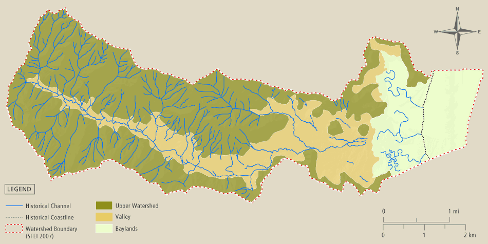
Miller Creek watershed is in eastern Marin County and flows into San Pablo Bay. The watershed can be divided into three sections based on general hydrology and topography: the baylands, the valley, and the upper watershed. The creek itself traverses all of these landscapes.
The Creek
Miller Creek’s drainage network consists of a mainstem channel and all of its tributaries. Some of the channels are perennial (have water flowing in them year-round) while others are intermittent (have flowing water seasonally), or ephemeral (have flowing water only after rainfall). Ephemeral channels are mostly restricted to the headwater reaches of the drainage network. The mainstem of Miller Creek is mostly perennial and supports steelhead trout in a viable fishery.
Watershed Topography: 3 sections
Miller Creek watershed is in eastern Marin County and flows into San Pablo Bay. The watershed boundary is defined by ridges to the north, west and south, and San Pablo Bay to the east. The watershed can be divided into three sections based on general hydrology and topography: the upper watershed, the valley, and the baylands. The drainage network traverses all of these landscapes
The upper watershed consists of the hills and tributaries that drain to the valleys. The soils are thin, with bedrock generally less than 5 feet below the land surface. The hillsides that face north or east get less direct sunlight, and therefore tend to be cooler and wetter than the other slopes, and much more forested. On still nights, cold air flows like water down the slopes and along the creeks, before dissipating across the valleys. The natural distribution of native forests in the upper watershed reflects the topography, hydrology, and patterns of air movement that have been relatively unaffected by the complex history of land use change in the valleys and baylands. Coyotes, bobcats and mountain lions all live in the upper watershed.
The Valley is defined as the relatively flat lands sloping gently toward the Bay between the ridges that delimit the watershed boundaries. The valleys consist of deep layers of alluvium - sediment eroded from the upper watershed and deposited downstream by the overflowing creeks. The valley area is a mosaic of past and present floodplains that were largely formed during the Pleistocene Epoch ending about 10,000 years ago, when the climate was wetter, the creeks were larger, and flooding was much more extensive. The main valley extends nearly to the upper limits of Lucas Valley from the upland edge of the baylands (near Highway 101). Most of the valleys are now occupied by residential suburbs.
The Baylands consist of all the lands below the historical upland limit of the tides. This includes the tidal flats, tidal marsh, and all the lands that would be tidal if not for the levees, dikes, roadways, tide gates, and other man-made structures that constrain the inland excursion of tidal waters. The historical and current ecology of the baylands is dominated by the tides, especially the formation of salty soils that strongly influence the distribution and composition of plant communities.