 |
4 Historical Ecology and Watershed Management
What is historical ecology?
Scattered throughout local and regional archives, historical information represents a valuable and often untapped resource for watershed management. Historical ecology is the scientific process of gathering, synthesizing, and analyzing the diverse maps, photographs, texts, and living memories that constitute the historical record of a watershed.
By revealing how a watershed has changed over time, historical data can help us understand the underlying causes of contemporary conditions. Understanding historical ecology can help identify new strategies for environmental management.
 |
In the Bay Area, landscapes have changed so much in the past two centuries that we often have little knowledge about how they used to look and function. As a result, we risk overlooking the existing opportunities for reversing historical trends and improving watershed health. With a historical perspective, however, new options emerge. For example, in the highly developed Silicon Valley historical mapping has identified several surprising opportunities to restore historical wetlands within the urban framework, providing flood protection and recreational benefits as well as habitat for native fish, waterfowl, and endangered species. With this information in hand, citizens and agencies are now restoring a significant portion of Laguna Seca, one of the South Bay's most important historical wetlands.
Understanding the historical landscape helps us recognize how to work with, rather than against, the physical and ecological processes that shape native habitats. Many of these now-forgotten historical processes and habitats may be better suited to present-day watershed conditions and social needs than the existing artificial conditions. For example, in some parts of the Bay Area, naturally intermittent streams with open riparian canopies prevailed historically, but are now uncommon. Such systems may be more sustainable during future droughts and water shortages than current riparian communities, which are often dependent upon imported water.
Understanding historical change can help address many of the challenges associated with local watersheds, including managing stormwater, flood protection, land erosion, and fisheries habitat. The past does not inherently represent what is needed now or in the future. But it helps identify restoration and management options — ones well calibrated to local landscape processes and history. It can reveal the resiliency and potential of the landscape, and suggest scenarios for moving forwards. This knowledge provides a basis for making informed decisions to maintain and improve the health of the local landscape.
Historical ecology methods used for this study
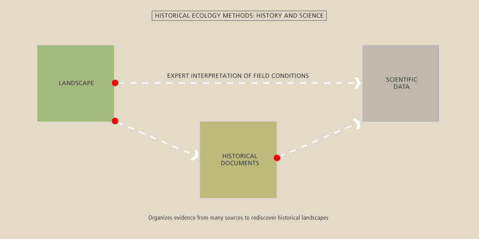
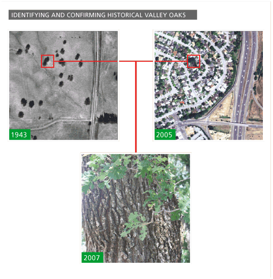
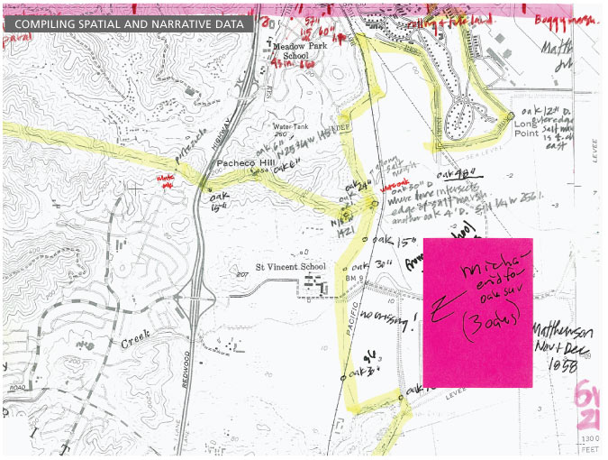
For this study, we acquired, interpreted and synthesized a wide range of historical documents, using methods described by Grossinger (2005) and Grossinger et al. (2007). The historic plan view of the Miller Creek drainage was reconstructed as a digital map in a Geographic Information System (GIS) at SFEI. The reconstruction began with a modern map of the drainage network obtained from the MarinMap website. Sections of the network were then appended, re-aligned, or deleted, based on all available historical evidence, to represent historical conditions. For the network west of US Highway 101, the best single source of historical information was the historical aerial photography produced by the USDA (1943). Aerial photography was prepared for the GIS through a digital correction process called orthorectification. These photos reveal evidence of the impacts of earlier agricultural land uses. Note that some of the headward channels and gullies that were mapped from the historical USDA aerial photos might have resulted from earlier grazing and other land uses, and therefore might not represent the channel network as it existed prior to Euro-American settlement. Many of the smaller, tributary channels in the upper watershed were mapped using a digital topographic model (DTM). In essence, the model estimates where runoff from adjacent or converging slopes is adequate to create a channel. The model results were corrected based on aerial photo interpretation.
 |
The historical riparian area around the mainstem channel of the Miller Creek drainage network was generated using a new GIS mapping technique (Collins et al. 2006) that is being used to map all of the riparian areas around the Bay1.
Other historical maps and photos were also obtained and analyzed in order to determine historical channel locations and other habitats. A complete list of these data can be found in the sources section
1 A standard riparian width coefficient was applied to the channel as a function of its size and the height of the riparian vegetation. The optimum width coefficient was found to be 25 meters for each channel bank.